Maps and Routing in Websites
Comparison between Google Maps and OpenStreetMap
The different appearance of the maps
Today, I will talk about the differences the two maps themselves have, but
also about their common features. To start off I want to talk about the
differences in the appearance of the maps. This is most easily explained with some
pictures, so here we go:
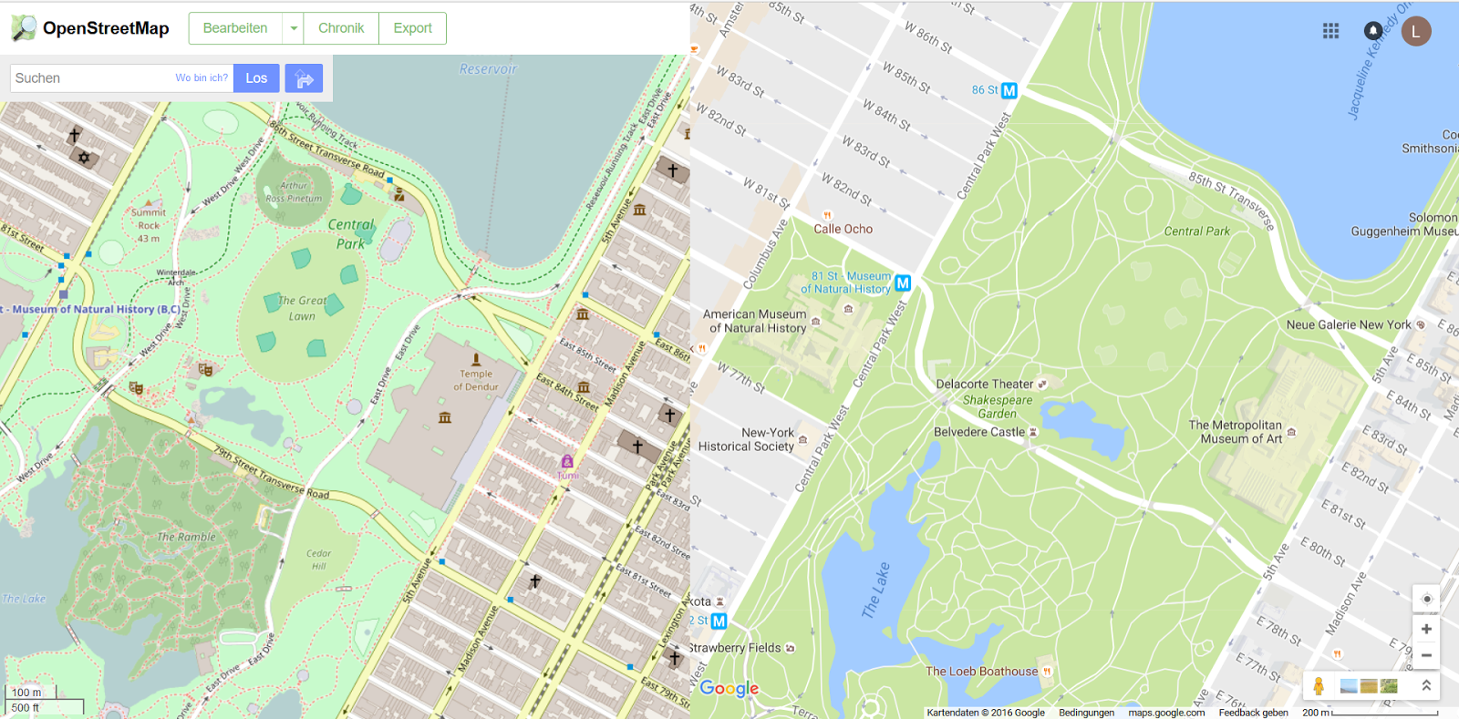 |
@OpenStreetMap
contributors
@Google Maps
|
In both pictures you can see the same place, Central Park in New York.
The one on the left is taken from OpenStreetMap, the right
one is from Google Maps. You will
immediately notice that the two maps have a different appearance: while Google
Maps mostly shows the name of restaurants, shops, museums, etc., OpenStreetMap
shows more names of the places in the park. This does not mean they are
not written in the respective other map, but the two maps just have different priorities of
which names they show. But not only are the names different, also the surfaces:
OSM (OpenStreetMap) uses more colours, but for some users taste, there could be too many,
whereas Google Maps sometimes looks a bit empty. But what applies for less crowded
places? Here you can see Reinswald, a place not so far away from where I live:
 |
@OpenStreetMap
contributors
@Google Maps
|
I allowed both maps auto-route the hiking path from the top end of the cable-way
to the so-called “Kassianspitz”, a mountain peak a few kilometres away.
OpenStreetMap suggests the shortest possible solution, using existing hiking
trails and gives me a route about 6.3 km long. But Google Maps lacks of these
hiking trails in many areas, for example in the one given here. For it, the shortest route is
going all around the mountains and approaches the peak from the other side. The
route that Google Maps calculated is 68.3 km long! The different result comes from the origins of both maps:
Google Maps belongs to Google, which documents the map on its own. OpenStreetMap
is open-source, and anyone can contribute to it, so maybe a resident of Reinswald,
maybe someone else, once documented the different trails that are offered in this area.
Anyone can contribute to OpenStreetMap, which makes it also
possible to document outlying places. If you want to use a map, be sure to check if the place you want to display, or
the trails and streets you need for your route exist in the solution you
prefer.
The different licenses
Another big difference is the licences both maps have: OpenStreetMap has,
as its name already suggests, an open license, whereas Google Maps uses the
Google copyright, with some additions. You can find more information here: Google Maps and OpenStreetMap. The use is
free for both, but, depending what you need the respective map for, you should
check these copyrights, especially if you need them for commercial use.
Which one is better?
I personally prefer OpenStreetMap, because of its appearance that has more
colours, and a lot more information. I also think that Google Maps is more
oriented towards business, it primarily shows shops, theatres and museums,
whereas OSM prioritises cultural names or names of important places. If you
only need a static map, I would still take Google Maps because its use is simple, but if you need more features, I would suggest using OpenStreetMap.
No comments:
Post a Comment